Translate

Friday, 15 April 2016

Kadadu National Park


I wasn’t quite sure what to expect from Darwin but I was excited to arrive. Having recently been in the southern extremes of Tasmania, I was now in the ‘Top End’ of the country. It’s here that I’d gain more interesting insights into the aboriginal culture and how it forms part of the enigmatic feel of the tropical Northern Territory. Although the wet season was approaching and the humidity was increasing, the next few months would be perhaps the most enjoyable of my entire Australian experience.

We only stayed a couple of nights in Darwin before hiring a car and heading into the wilderness again. This time we’d be backtracking south to Adelaide River. The crocodile tours here make this is a popular destination but we were set to explore the remarkable landscapes and Aboriginal history of the Kadadu and Lichfield national parks…


A huge cathedral termite mound


Kadadu National Park is a huge area with a geographical size larger than Israel. It’s more than just a national park – it’s an educational and cultural adventure set amid extraordinary natural beauty. We had four days to see and experience as much as we could. Unfortunately we couldn't get to the scenic highlights of Jim Jim and Twin Falls without a 4WD but being so late in the dry season, the falls have fallen so to speak.  There is water all year but they are a lot more spectacular after the wet season in March or April.

There were other parts of the park which weren't accessible either but we still had plenty to see and do.  From Darwin, it's a 300km drive into Jabiru, which is town in the centre of the park. On the way we stopped at Mamukala to watch thousands of magpie geese feeding on the floodplain. Jabiru is Kakadu’s major service centre and even has a gold course but it exists mainly because of the nearby uranium mine. It’s possible to take a tour of the mine but we had to find a suitable place to camp.


Ancient Aboriginal rock art


We spent that night at a place called Ubirr which has a nice walk and some fascinating Aboriginal rock art.  It was incredible to realise that this work was done over 20,000 years ago! A park ranger was starting a talk as we arrived at one of the most significant sites.  We then followed him up onto the huge rock outcrop where he gave another talk about the floodplains and surrounding country.  Enjoying views of Arnhem Land and watching the sunset up there was a magical experience.


Crossing the river to Arnhem Land


The campsites of Kakadu are dusty earth and dry leaves. However the facilities were good and during the dry season there are often slide show presentations given by park rangers.  In our three nights, we heard talks on the six seasons of Kakadu, buffalos in the park and crocodiles. The six seasons recognised by the local Aboriginal people create an annual cycle through the wet and dry times of the year.

The next day we explored an area called Nourlangie Rock.  I did a couple of walks here including one along the East Alligator River.  I was hoping to see a salt water crocodile but unfortunately I never did. The second walk went through some fascinating rock formations where layers of weathered sandstone have created all kinds of interesting outliers. The Anbangbang Shelter in this area was used as a shelter for thousands of years and features artwork that was repainted in the 1960’s.


Lovely views from Nourlangie Rock


Unfortunately the crocodiles in the park mean virtually no swimming anywhere. (Kakadu becomes Kakadon't!)  The only totally safe places to swim are the pools at Jabiru and Cooinda.  With daily temperatures of about 38C, we swam at Jabiru before going to the nearby Bowali Visitor Centre.   Cooinda is in an area called the Yellow Water and where we spent our third night.  It was a lovely camp site with good facilities and green grass.  After a refreshing swim, I went on a final unsuccessful quest to see a crocodile.


Hiking in nearly 40C heat


We decided to take a shortcut across an unsealed road on the way home.  Everything was fine until we got to a river ford with about a foot of sand in the bottom of it.  I thought about going through but not for too long.  It would have bellied for sure so we had to go all the way back and an extra 300km around the long way.  I hate it when that happens but better safe than sorry as they say!


Friday, 8 April 2016

Northern Territory Road Trip


Our travelling group was abbreviated to just three while we were in Alice Springs.  One was returning home to New Zealand and another couple were going south to Adelaide.  So together with the Irish girls Denise and Bridget, we took on another campervan relocation adventure. This time it was a 4WD with a tent on the roof that popped up. There was also another tent for the ground and all the camping equipment that we could ever need, including a fridge and cooker. 1,500km to be done in three and a half days.

Another vehicle, another destination

Our first night was 400km north at the Devils Marbles.  The 'campsite' was the dusty earth of the car park.  No green grass here but plenty of the large and incredibly annoying outback flies. The only relief was sunset when they’d disappear but be replaced by mosquitoes. Never mind the dingos and snakes that were probably lurking out there. Oh the joys of wilderness Australia! Still, the mighty sandstone boulders are more impressive at sunset so I was happy to be there for that.

It was a restless night. A breeze came up and we spent more time listening to the tent flapping than actually sleeping. Amid an onslaught of flies, we quickly dismantled camp and got on the road the next morning. We stopped in Tennant Creek for breakfast and decided to use the toilet a local campground.  This turned out to be a bad idea because when the manager found us he demanded that we pay $10 or else he’d call the police and have us arrested for trespassing.

Tennant Creek Caravan Park

After an argument we declined to pay and got back into our vehicle. I thought that was the end of the matter until I saw in the rear view mirror the manager’s car looming large behind us. He began to chase us around the streets until I realised that perhaps the heat and flies had really gotten to this guy! I pulled over near the police station and pushed some money through a window I was too afraid to fully open. After receiving the money, he ranted angrily at us before going into the police station to report us anyway!

We had to follow him in to sort things out before finally getting on our way again. The local officer told us before we left that he has wasted their time before and almost apologised for his erratic behaviour! All’s well that ends well as they say.

As we travelled north up the Stuart Highway, I noticed a sign indicating that we were about to cross 'Tomlinson Creek'. When I got out for a look I realised how hot it was outside.  Although it was only September the temperature must have been close to 40C. The poor creek had nothing flowing in it so I did my little bit to help. We were grateful to finally make camp that evening at a nice little place called Dunmarrar.  Here we had grass to camp on and there was even a swimming pool.

Tomlinson Creek

Not far north and a few kilometres off the highway is Daly Waters, population 25. This little dot on the map has an interesting history as an important staging post in the early days of aviation. Nowadays it is famous for its pub that just about everyone stops at. Its liquor licence dates back to 1893 making it the oldest pub in the Territory. Decorated with business cards, banknotes, bras and other memorabilia left by travellers, it made a great place to break the journey with a beer and a laugh.

Daly Waters pub

Our final night was spent at Katherine Gorge in the Nitmiluk National Park.  It's a beautiful area and I'd love to have spent another day there.  We arrived about 5pm so just had time to walk up the gorge, get a few photos and have a swim in the Katherine River.  While swimming alone in the middle of this river at dusk it suddenly occurred to me that crocodiles may be lurking in the dark waters.  I quickly retreated back to the safety of the river bank!

Our last day included a stop at the Edith Falls in a different part of the park. I did a petty 45 minute walk and had a quick swim.  We had to have the camper back by 3pm and when we got to Adelaide River I realised we had just 85 mins to drive 120km!  We were told that even one minute late would cost us $300! So, the last leg of the journey became a rather mad dash and I was grateful for the absence of a speed limit in the Northern Territory.

Sunset at Katherine Gorge

We drove into Darwin at 2.45pm but we still hadn’t made it. We had to refuel the vehicle like a race pit stop and then locate the rental car office without the aid of a GPS. As we drove in the gate I glanced at the clock on the dashboard that read 2.58pm. We’d made it! It probably wasn’t a great way to arrive in a city that is renowned for its relaxed vibe but we were there on time, in one piece and very happy.


Friday, 1 April 2016

Alice Springs


Nearly 150 years ago Alice Springs was merely a lonely telegraph station located on the Stuart Highway approximately halfway between Adelaide and Darwin. Until 1933, its name was actually Stuart but it was changed to avoid confusion with the town of Sturt in South Australia. Although it is still surrounded by red desert sand and rugged mountain ranges, it has developed from a frontier town into a modern regional centre. I’d always dreamed of coming here to not only explore the surrounding area but learn more about the Aboriginal culture. I loved my time here.


The sandy Todd River


The city is built around the Todd River but for most of the year it's just a huge bed of dry dusty sand that awaits the drought breaking rain. Beside the river is one of the most interesting places - the old telegraph station.  Along the Stuart Highway are various reminders of the telegraph line that once linked Adelaide to Darwin and then to England via a submarine cable.  The whole project was completed in 1872 and was an amazing feat for that era.  Alice Springs was a vital point in the line and the original station is now a museum.


Old Alice Springs Telegraph Station


I visited the Royal Flying Doctor museum and communication base.  The Flying Doctor was the vision of a man called John Flynn. In the 1930's he wanted to develop a 'mantle of safety' for people living in remote outback locations and recognised that the plane was the only genuine way to make this a reality. The first flight was actually made from Cloncurry in Queensland but Alice Springs is a very important location in the modern service.

It was interesting to see how it has developed from that first flight in a plane that had no radio communication and very limited medical supplies.  Thanks to technology and a lot of hard work, it's now an operation involving 45 aircraft flying from 23 bases around the country and employing more than 600 people in various capacities. Altogether, these dedicated health workers provide 24-hour emergency medical service to an area of about 1.25 million square kilometres.


Memorial to John Flynn


I enjoyed my visit to the Olive Pink Botanical Garden which was named after a prominent anthropologist. The gardens are a network of meandering trails that lead through a lovely display of plants and trees that grow in arid zones. It contains over 500 central Australian plant species including bush food and medicinal plants. At the end of the day I did the gentle climb up Meyers Hill to watch the sun set over the city. The other good city viewpoint is across the riverbed at the top of Anzac Hill.

On my final day I hired a bike and did the ride out to a place called Simpsons Gap in the MacDonnell Ranges National Park.  Most of the 25km is on a beautiful smooth cycle track through a harsh but very beautiful landscape. Simpsons Gap itself is where millions of years of erosion and weathering have created a gap in the quartz rock.  It was difficult to imagine how any erosion could possibly happen while I was standing on a bed of sand!  Still, it’s an area of stunning beauty I was lucky enough to see a few little rock wallabies while I was there.


Simpsons Gap 


Being September, we were fortunate to be in Alice Springs while the annual Desert Festival was on. It started with a street parade and free concert down beside the river.  For the next 12 days there were various events such as art/craft displays and workshops, concerts, story telling, dance and theatre etc. I could easily have stayed a bit longer but the road was calling my name again and this time we’d be heading north to Darwin.


Friday, 25 March 2016

Uluru and The Olgas


After the climb we visited the Aboriginal Cultural Centre and then to the sunset viewing area.  We joined in a large collection of cars, campers and people with their cameras ready.  This was more than a sunset; this was an event!  The evening sun illuminated the rock in a deep orange colour which then became a series of deep reds. As the sun set over the horizon behind us, it transformed again into a faded brown colour and the sky filled with different colours behind it. It was an majestic and truly unforgettable sight.


Uluru at sunset

We stayed at a campground about 20km from the rock so that we could return for sunrise in the morning.  We nearly missed it because of a flat battery but just made it after some frantic asking around and nifty work with some jumper leads.  The early morning sun creates similar colour patterns to the evening, but in reverse order and on the opposite side.  There was another crowd there to witness the new day dawning and after getting our photos we had breakfast and prepared for the 10km base walk.


Uluru base walk

The hike around the base of the rock offered great views of its contoured surface, Aboriginal artwork and culturally significant sites such as caves.  It was even more impressive in the knowledge that about two-thirds of the rock is believed to be lying under the sand! It took about two hours to complete the 10km walk but a couple of people nursing a hangover decided that sleeping in the car was a better option! At mid-morning we left for Kata-Tjuta (The Olgas) - one of the few drives that we actually completed in under an hour!


Kata-Tjuta (The Olgas)

The Olgas are a striking group of domed rocks huddled together to form deep valleys and steep-sided gorges. There are two walks at the Olgas so after quickly doing the 2.6km Walpa Gorge Trail, I then hiked the longer 7.5km Valley of the Winds.  There are a couple of lookout points that offered wonderful views and some great photo opportunities of the unique landscape.  It was only towards the end that I realised walking 20km in the desert after drinking cask wine till 3am is not that easy!


Hiking the Valley of the Winds trail

That was the final stop of our tour and we set an immediate course back to Alice Springs.  Our original plan was to camp somewhere along the way but the general opinion was that everyone was just too tired and wanted a real bed!  So I drove a quiet, but very content little group the 450km back to our hostel where a hot shower and restaurant meal was oh so good!


Friday, 18 March 2016

Kings Canyon and Uluru


It’s funny the way distances can be deceiving. Somehow, I imagined that once we arrived at Alice Springs, Ayers Rock (Uluru), The Olgas and Kings Canyon would be within easy reach. It doesn’t look far on the map, but our exploration of these amazing places would mean another 1,500km of travel! It’d take three days but what a great three days it was!


Arriving in Alice Springs

Our travelling group was enlarged by one the night before we left after meeting a friend from Cairns at the hostel here.  Travel offers these little quirks of fate and we were all happy to make space for her.  There wasn't a lot to spare though because we only had an eight-seat car. However, with some careful packing we managed to fit the tents, sleeping bags, camping gear, food and the alcohol we needed and hit the road again.


Setting off on another desert adventure

For this trip our chariot was christened (I've been through the desert on a) 'Horse With No Name' and we arrived at Kings Canyon late afternoon.  There are a couple of walks to do so we chose the shorter one that goes along the base to an area called the Garden of Eden.  It's not as idyllic as it sounds but it had a large pool of water which was nicely shaded by the surrounding trees.  The water wasn't exactly pristine but we enjoyed a swim anyway after a hot day travelling.


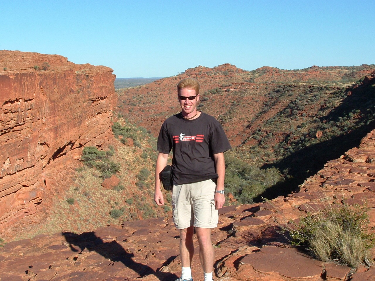
The next morning I did the 6km Canyon Rim Walk that firstly ascends and then follows around the edge of the canyon.  It was spectacularly beautiful and many travellers rate it as a highlight of their trip to the area.  The best views were at the far end where you can see right back to where the canyon opens.  All along the track though there were fascinating rock formations and desert plants.  It took about two hours to complete the circuit before joining the others and leaving for Uluru.


Rim Walk, Kings Canyon

We stopped along the way to photograph a group of feral camels and it wasn’t long before a huge monolith appeared on the horizon. Our initial thought was that it must be Uluru but it had a unique table-topped shape that is different from the distinctive curves we’d all seen in photos. What we were actually looking at was Mount Connor and we received even better views of it from the lookout just before turning onto the Lasseter Highway. Once we made the turn the majestic Uluru was waiting and looming ever larger as we approached.


The imposing sight of Uluru

Uluru is undoubtedly an awesome sight.  It has a powerful presence and I could see immediately why it is sacred and so revered by the traditional Aboriginal owners. Through the day, it seems to have different moods that are represented by its changing colours. The mid-afternoon sun had turned the rock a ochre-brown colour and for the boys it was our immediate mission to climb it.  The girls decided it was either too challenging or preferred to abide by the plea not to climb out of cultural respect.


350 metres above the desert!

Personally, I thought the climb was an awesome experience and didn't feel any sense of being culturally disrespectful.  The first part is very steep and requires the help of a chain to pull yourself up.  Once that initial section was negotiated, it became easier as we continued on to the summit which is some 350m above the car park.  There wasn't a cloud in the sky so we got amazing 360 degree views over the outback.  In one direction was Mount Connor we'd seen earlier and in the other was the distinctive shape of The Olgas.


Friday, 11 March 2016

Going West


The second day took us across to a place called Cloncurry which is famous for a couple of reasons.  Firstly, is that it holds the record for the highest temperature ever recorded in Australia - 53.1C back in 1889. It's also the first place that a flying doctor flight departed from.  We stayed just outside the town because the camper was completely self-sufficient and didn't need to be at a camp ground.  The only thing we missed out on was not being able to use the TV/DVD player and microwave.


Warm welcome to Cloncurry

The morning of the third day I decided to leave before the van and run for an hour or so.  By the time they filled up with fuel and water I’d run about 24km through the desert heat.  Then I was the one that had to be filled with fuel and water! I enjoyed the experience and even had a group of about 20 cattle jogging along with me on the other side of the fence for a couple of kilometres. From where they picked me up, it was only a short drive to the mining town of Mount Isa. It’s best at sunset but we took in a quick panoramic view of the town from the City Lookout before pushing on.


We aimed to get to Three Ways for our third night. This is the aptly named point where the Barkly and Stuart Highways meet. From here, it's north to Darwin, south to Alice Springs and east back to Townsville. However, distances are vast and we ended up staying in a rest area about 150km short of our target.  It gave us the opportunity through to enjoy a silent, starry night and a beautiful sunrise early the next morning. We then saddled up and started driving because it'd be a long day with nearly 700km to cover.

 
Outback sunset

We had breakfast in the Northern Territory town of Tennant Creek which was established as a result of a small gold rush in the 1930’s. Today about half the population is of Aboriginal descent and it services a vast region of cattle stations and indigenous communities. Many travellers have little choice to stop here because it’s the only town between Katherine, 680km to the north and Alice Springs, 511km to the south. Convenient maybe, but it is also dusty and rather unattractive so we didn’t stay long.


Barrow Creek Telegraph Station

The landscape changed again down the Stuart Highway.  At the Queensland/Northern Territory state line the land was flat and stretched as far as the eye could see.  Closer to Alice Springs, the landscape became more undulating and the horizon was punctuated with brown hills and rocky outcrops. We stopped at Barrow Creek, which has a historic telegraph station and the most authentic outback pub you could imagine.  We had a beer and enjoyed the local ambience for a while before continuing on our way.


Devils Marbles

Our last stop before Alice Springs was at the gigantic and precariously balanced boulders called the Devils Marbles. For the Aboriginal people, they are known as Karlu Karlu and the rocks are believed to be from the Rainbow Serpent. The ‘marbles’ are actually the rounded remains for a granite layer that has eroded over aeons. Either way, the phenomenon of huge boulders seemingly balancing on each other is an extraordinary sight and we all enjoyed getting some photos before doing the final 400km down the road to our final destination.


Friday, 4 March 2016

Into the Outback


By September, the dry season in Cairns was coming to an end. It was the perfect time to continue the journey and my next destination would be some 2,500km southwest across the Australian outback. Amid the vast surroundings of the red desert, I was headed for Alice Springs and I was delighted to have five friends that I’d be sharing the overland adventure with.

Our transport for this epic journey was a six-berth campervan that a hire company needed to relocate from Cairns. The arrangement was that we only paid $25 a day and in return we had three and a half days to complete the distance. We christened the campervan "Priscilla, Queen of the Desert" and she drove like a dream. It was like an apartment on wheels complete with shower, toilet, cooking facilities, microwave and DVD player.


Priscilla, Queen of the Desert

The best route to Alice Springs is going down the coast to Townsville and then west through Mount Isa.  When we met Stuart Highway near Tenant Creek, it would be a six hour run south to our final destination…

The scenery on the five hour drive down the north Queensland coast to Townsville would be in stark contrast to what we’d see for most of the journey. At various times we had mountain ranges on one side the Pacific Ocean on the ocean. There was lush green rainforest and fields of sugar cane. The first town we passed through was Innisfail which is rich in art deco buildings of the 1930’s. Aside from sugar cane, this is banana country and there are plenty of plantations in the area.


Big golden gumboot, Tully

Not far south is the town of Tully is the sugar-mill town of Tully. The big golden gumboot at the town entrance proudly boasts that it is the wettest place in Australia. The upside to this is that it’s a great place to experience white water rafting in the nearby Tully River. It’s also just a short drive to beautiful Mission Beach where the World Heritage rainforest meets the Coral Sea in a 14km stretch of palm-fringed inlets and beaches. Aside from hiking and various water sports, it’s also one of the closest access points to the Great Barrier Reef.

So we’d love to have stayed a day or two but we were on a schedule and had to keep moving. The city of Townsville would be the ideal place to stop for lunch and more fuel. We decided it would be a great idea to eat our sandwiches on the landscaped waterfront esplanade. It’d be the last that we’d see of the ocean for quite some time!


The Strand, Townsville

The landscape changed as we drove inland. Lush green rainforest, banana plantations and cane fields were replaced by tussock-like grass, gum trees, rocks and earth which became a distinctly red colour as we moved toward the Northern Territory. We were in the awesome frontier of the Australian outback. It’s harsh country that also has a unique beauty to it. This would be a road trip like no other I’d ever done and we all had a sense of excitement about what we were experiencing.

Dinosaur Museum, Richmond

We stayed the first night in a truck stop at the dusty town of Charters Towers. There’s really nothing of interest here other than the impressive road trains with four trailers that were also parked up there for the night. The next day we’d cross the Great Dividing Range and truly appreciate the sheer size of the country we were traversing. The dusty opened wide and the sky above even wider. As far as the eye could see, the sun was beating down on the ancient landscape in a relentless but almost mesmerising way.