Translate

Friday, 26 February 2016

Diving the Great Barrier Reef


My first time scuba diving could almost be likened to having sex for the first time. I had to be directed in what to do but I was clumsy it was also a painful experience. Ironically enough, it was my ears that were giving me the trouble! I must have missed the all important memo that stated: “Ensure that you equalise the pressure in your ears as soon as you submerge under the water”. I waited until I was a metre or two below the surface before attempting my first equalisation.


Learning in the swimming pool

It was too late and I couldn’t relieve the pressure. It was painful and the usual tricks of swallowing and jaw movement weren’t helping. The doctor’s words came back to my mind: “I can’t let you go diving with only one good ear. Imagine if something happened to that?” Maybe the good doctor was right after all. What was I doing risking my hearing? As the rest of my group made their way down the rope I languished near the surface wondering if I’d be able to join them.

“Are you okay?” my dive instructor asked me with a questioning thumbs up. “Take a wild guess whether I’m okay” I wanted to reply but communication under water didn’t allow for such words. I pointed to my ears and indicated I wasn’t sure. He understood and waited with me while I desperately tried to resolve the problem. After a long few minutes I had relieved enough of the pressure to get down and join my group. As they say, there’s one in every crowd and today it was me.


Off the back of the dive boat

After an uncomfortable 35 minutes I was glad to be back aboard the dive boat. After removing all my gear I needed the bathroom. It was there in the mirror that I noticed a faint line of blood across my cheeks where my mask had been sitting. “Oh great” I thought, “the pressure did rupture something in my head and it’s been bleeding out my nose”. I quickly tested my hearing by talking to myself. It all sounded okay and when I told my dive instructor he told me it’s not too unusual and not to worry.

Fortunately things improved and I began to enjoy my diving. I was able to do the various tests to get my open water certification and took some confidence into being able to complete the advanced course. This included additional challenges such as doing a navigation dive, descending to greater depths and also several night dives. It took some courage to submerge into the pitch black ocean at night but once the initial apprehension was overcome it was a unique and thrilling experience.

 
The wonder of the Great Barrier Reef

The Great Barrier Reef is a marine wonderland and home to some of the greatest biodiversity of any ecosystem on earth. Aside from over 30 species of marine mammals, it is also home to countless types of fish, coral, molluscs and sponges. As much as I had the privilege of seeing, I was merely scratching the surface of this wonderful world that is so vastly different to our own. As I admired the amazing array of brightly coloured fish and coral, I often thought that we must do all we can to protect and nurture such an extraordinary environment.


Friday, 19 February 2016

Preparing to Dive


Although it wasn’t an organised tour, I had a great day with a couple of friends going initially up to the pretty sands of Trinity Beach and Palm Cove. I decided that if I ever became rich, I was coming back to this place on a luxurious holiday! After strolling the beach and swimming we headed inland to the township of Kuranda. Set amid pristine rainforest, is a popular tourist destination for the markets and various sanctuaries for butterflies, birds and even snakes. While others shopped, I did the Jungle Walk trail to the Barron Waterfall.


The idyllic Palm Cove

For many, the attraction of Kuranda is in the journey as much as the destination. While we took the road up the hill, there is also a scenic railway that winds 34km from Cairns up through picturesque mountains and 15 tunnels. This line took five years to build which isn’t bad considering it was opened in 1891! Another popular and certainly the most spectacular way of enjoying the Kuranda rainforest is on the 7.5km gondola cableway. Maybe something else I’ll do when I’m rich!


Kuranda Scenic Railway

As I mentioned, Cairns was where I ticked ‘scuba diving’ and ‘Great Barrier Reef’ off my bucket list. After working on the dive boat for several weeks it was now time to get my diving medical and begin my first course. A mere formality I thought to myself as I idly ticked yes and no boxes on the doctor’s form. I was fit and healthy but as I sat in the doctor’s office I could sense a problem emerging. “Tell me about your hearing loss” the doctor asked me.

“Pardon me?” I replied but it seemed that this wasn’t the moment for joking. I am virtually deaf in one ear and the doctor didn’t like this at all. “I’m sorry” he informed me “but we can’t issue you a dive medical with only one good ear. “It’s too risky. I’m sorry”. He is sorry? What about me! I was totally devastated and as I returned to the hostel I was nearly in tears. This was a dream being crushed by the red pen of a doctor. Besides, it was my only way of being paid for all my work.


Down Under Dive boat Osprey V

The silver lining of my dark cloud was my friend at the hostel who told me not to worry and assured me that I’d be able to go scuba diving. “How can I possibly go without a medical certificate?” I reasoned with her. She smiled at me and gave me a wink. “You simply go to another doctor” she replied “and don’t disclose anything about hearing loss”. “But they’ll test me won’t they?” I insisted. “Probably not” she continued to reassure me, “they’re too busy for all that!”

And so it was. With a little tick in the wrong place on the ‘Hearing Loss’ question, I soon had my precious medical certificate and was making a booking to begin my PADI Open Water course. Initially there was some theory work to do and which involved becoming familiar with all the equipment. There was also a lot of safety information to learn before the baby steps of getting submerged in the swimming pool. Finally, the big day arrived: it was time to begin scuba diving on the reef.


Friday, 12 February 2016

North to Cairns


One of the great things about travelling Australia is that you can move with the seasons and get the best weather. In other words, when winter was starting to set in down south, I headed north to Cairns in the north of Queensland. Here the tropical rain and humidity was receding and I could settle into a comfortable climate of bright sunny days with average temperatures in the mid 20’s. After taking some time to be a tourist I’d settle in, earn some money and learn to scuba dive before continuing my journey.

Although it was April and the wet season hadn’t yet dried up, I was keen to get to the beach for a swim. But like many tourists I was disappointed to find only mud flats that stretch along beside the esplanade boardwalk. To make up for it though is the wonderful artificial swimming lagoon which has been created on the reclaimed foreshore. Like so many other travellers, I enjoyed a few lazy afternoons there with friends that I’d met at my hostel. From the lagoon, it’s a pleasant walk around to the marina and Trinity Inlet where the cruise boats and daily island ferries leave from.


Cairns swimming lagoon


The beaches are just north of the city and the most appealing of them is the stretch of white sand at the curiously named Yorkeys Knob. This was the first stop on a little day trip I had up to the resort town of Port Douglas. It’s a nice drive up the Captain Cook Highway and the town itself is a relaxing place for those looking to enjoy tropical north Queensland without the backpacker crowd that is a perennial part of Cairns. It’s more expensive though and most accommodation is a range of self-contained apartments or upmarket resorts.


City view from the Botanical Gardens

I played tourist while waiting to find a job in Cairns. A favourite place quickly became the Flecker Botanical Gardens which included some lovely walking tracks through the rainforest. One in particular offered viewpoints over the city in one direction and the airport in the other. Through the dry season this became a running circuit that I always the challenges and rewards of. I visited the small museum and always enjoyed the ambience of the night markets.

Cairns is a nice town that became my home for five months. It didn’t take long to realise though that it is a gateway to surrounding attractions more than anything. Literally hundreds of tours bus, boat, fly or drive out of the city on a daily basis. The most popular of these is obviously the Great Barrier Reef and I was fortunate to be able to get a job with a dive company helping with the annual maintenance of their ship. Instead of receiving payment in cash, I was compensated with being able to complete my open water and advanced scuba diving certification.


Snorkelling on the Great Barrier Reef

The other job I was working at the huge flashpacker resort of Gilligan’s. For most guests, it’s expensive and impersonal but I was in a room with other staff so we all become friends and had a good time at a discounted rate. Working as a kitchen hand here was probably the most unglamorous work I’ve ever done but it provided badly needed money and a place to stay. It also meant getting free drinks at the bar and at least one good meal a day which many backpackers couldn’t lay a claim to!


Gilligan's - my north Queensland home

There were other perks as well. Every Thursday the guys from the AJ Hackett Bungy Jumping site would come in for promotional work and in return the Gilligan’s staff would receive free jumps. After about a month, Gilligan’s began doing yacht tours out to the reef so I enjoyed a complimentary day of cruising, swimming and snorkelling. Aside from the hostel, accommodation, restaurant and bar, we also had a tour desk that kept us in the loop for good deals and last minute options.


Friday, 5 February 2016

Hobart


Our final Tasmanian destination was the capital of Hobart. Sitting between the towering Mount Wellington and the Derwent River, Australia’s second oldest and southernmost capital city would have plenty for me to enjoy over the next three days. 

I used the first of these days to do the climb up Mount Wellington.  And what a great day it was! The five-hour return hike through temperate forest opens out to a rocky and almost lunar like landscape at its peak of 1270m. The lookout which is also accessible via a road that winds up from the city offered spectacular views of the city, Derwent River and beyond.  In fact I could see Bruny Island, Tasman Peninsula and even Maria Island to the north. I hiked down another track to view the Organ Pipes which is a sheer rock formation about halfway up the mountain.


Lookout at the summit of Mount Wellington

I split the other two days of my time between the city of Hobart and across the Derwent River at Rosny and Bellerive.  I was particularly interested in visiting Bellerive Oval which is the home of Tasmanian Cricket and contains an interesting museum.  The other feature over that side of the river is the gun battery built in the early 1800's. It was commissioned because of the misplaced fear that Hobart would be invaded by the Russians.  A lot of time and expense was put into the project but it was destined to never fire a shot in anger.


Bellerive Oval on the banks of the Derwent River

Spanning the Derwent River between Hobart and Belrieve is the Tasman Bridge which was opened in 1966. Just nine years later it was hit by a huge ship destined for further up the river.  It caused part of the structure to collapse onto the vessel and it sank as a result.  Several cars plunged into the river and a total of twelve people died in the disaster.  The aftermath was commuter chaos with people suddenly unable to reach the city.

The second bridge a few kilometres up the river wasn't built at this stage.  Ferries were employed until the bridge could be rebuilt and two huge piles that look slightly different to the others is a lasting reminder of that day.  There is a sign on the footpath now that reads "Warning - do not cross the bridge if large ships are approaching"!


The Tasman Bridge

The focal point of Hobart city is the waterfront at Sullivan’s Cove and the iconic Salamanca Place. This picturesque row of four-storey sandstone warehouses is some of Australia’s best preserved historic architecture and dates back to the 19th century whaling era. Nowadays it is a vibrant cultural precinct and the buildings are used as galleries, studios, performing arts venues, restaurants, bars and shops. There is a large Saturday market here offering a maze of bargains, buskers, food and arts.


The historic buildings of Salamanca Place

The nearby waterfront includes Constitution Dock where the annual Sydney to Hobart yacht race finishes. This whole area is a great place to explore or simply sit and watch the various harbour activities. Just a few minutes walk from the dock is the Tasmanian Museum that features an interesting collection of colonial relics and Aboriginal art. Also a very short walk from the waterfront is Battery Point which is a nest of 19th century cottages and lanes which takes its name from the 1818 gun battery that once stood on the promontory. 

On my final day in Hobart I did a run along the bike trail that leads up the valley beside the Derwent River. As much as I would have liked to, I didn’t make it all the way to an area called Claremont which is where the Cadbury chocolate factory is. Instead I explored Queen’s Domain and the beautifully kept botanical gardens. It was a final opportunity to enjoy some serenity and reflect on the wonderful time I’d had before embarking on the next phase of my journey.


Friday, 29 January 2016

Maria and Bruny Islands


We camped that night at Triabunna which is close to where the ferry leaves for Maria Island.  It was cold but waking early enabled me to take some beautiful views of the sunrise over the harbour.  Maria Island was declared a National Park in 1972 and offers an interesting history of convict and industrial ruins. It is also appealing for its beautiful natural features such as beaches, forests and limestone cliffs.


Sunrise at Triabunna

After exploring the old Commissariat Store and remains of the Darlington convict village, I did the 4-hour return hike up a peak called Bishop and Clerk. This is the highest point of the island. It offered great views back towards the mainland and out to sea in the other direction. The highlight for me though was seeing the art of nature so beautifully in the Painted Cliffs.  These extraordinary cliffs have been stained various colours by water running down their rock faces.


Painted Cliffs, Maria Island

After the ferry returned us to Triabunna we drove south to Kettering for the ferry across to Bruny Island the next morning.  We arrived 20 minutes before the sailing at 7.45am and couldn't understand why we were the only car waiting and there were no crew anywhere.  It didn't take too long to realise that daylight saving had finished and we were actually an hour early!

The islands of North and South Bruny are separated by a thin strip of sand dunes called The Neck. They are both rugged and very scenic, especially the south.  Our initial destination was Adventure Bay - a place with a rich history of whaling stations and a shelter for explorers like Tasman and Cook.  I did the Fluted Cape walk there and although light rain spoiled views out to sea, the highlight of the walk is awesome sea cliffs.  Bruny is famous for its wildlife and as I returned to the car and I was fortunate to see a rare albino wallaby.


Dennes Point, North Bruny Island

We did a walk around Cloudy Bay before going to Cape Bruny on the southern coast of the island.  This windswept point has an old lighthouse built in 1836 that has expansive views over to mainland Tasmania’s southernmost reaches.  The cold southerly wind meant we didn't stay there very long and drove right up to Dennes Point at the northern tip of the island.  It was a much warmer and more pleasant place to wait for the ferry which departed early evening.


Friday, 22 January 2016

Exploring Tasmania


The following day we went to Stanley - an attractive and historic coastal town most well known for The Nut.  This is an extinct volcano that we climbed and then walked around the top of.  It provided wonderful views both out to sea and back over the town itself.  After lunch at the beautiful Table Cape we headed south to town of Strahan on the rugged west coast.  We only had time for a drive through before going out to Ocean Beach to camp for the night.


Highfield Historic Site, Stanley

Our next destination was the mining town of Queenstown. To get there we had to traverse the extraordinary Lyell Highway that winds its way through a surreal, almost apocalyptic landscape of eroded gullies and scarred hillsides. This is the legacy of environmentally destructive mining and the town itself has a pioneer feel to it. The other option of travelling from Strachan to Queenstown is on the West Coast Wilderness Railway which is a four-hour train journey through dense forest and over wild rivers.


Mining town of Queenstown

Southeast from Queenstown is the Franklin-Gordon Wild Rivers National Park where I hiked to the Franklin River before we continued on to Mount Field National Park.  It was late afternoon but we just had time to do a two-hour walk to see the Russell, Horseshoe and Lady Baron Falls.  All very pretty but would have been impressive with more water.  At the end of summer, much of Tasmania seemed to be dry and brown.  We also walked though the 'Land of Giants', an area of huge swamp gums - the world's largest flowering plant.  The tallest one stands at a massive 79 metres.

In the National Park, we drove up to Lake Dobson which is over a kilometre above sea level.  It was cold up there so we decided to camp out in the enclosed shelter instead of pitching tents. Despite the rather threatening weather, we walked to one of the alpine lakes in the morning before leaving for Hobart.  It was nice to have the luxury of electricity, a comfortable bed and hot shower after all that.


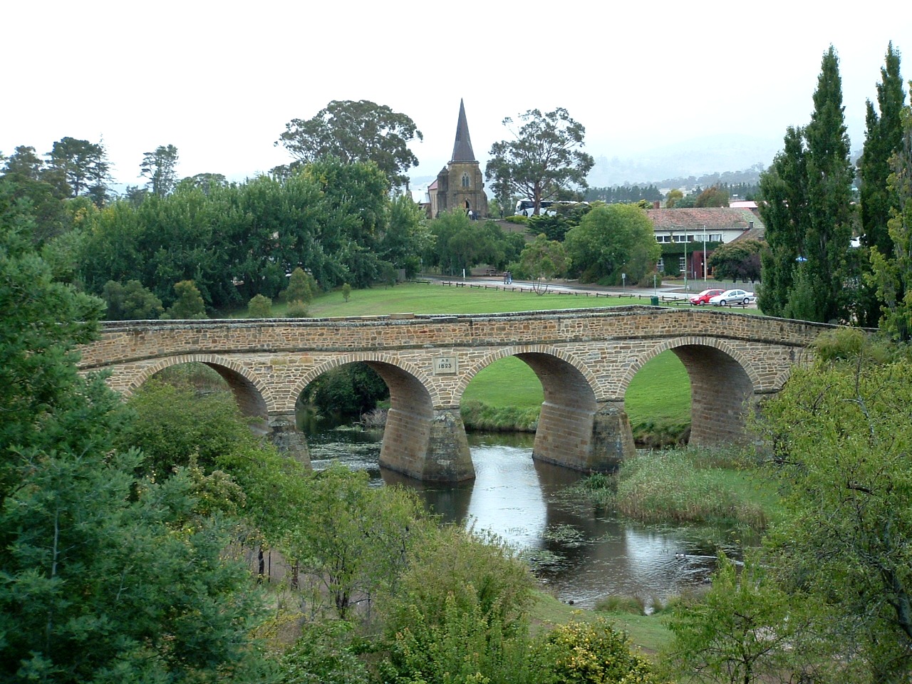
Old bridge and church of Richmond

We didn't have long to catch our breath because we were on the road to the Tasman Peninsula the next morning.  It was a day where we had to dodge a few showers but it wasn't too bad.  Our first stop along the way was the former military outpost and convict station of Richmond. Today it is a historic town featuring an old stone road bridge and various 19th century buildings including churches, courthouse and gaol. We also stopped at the Tessellated Pavement which is a beach where the fascinating rock formations look like a stone pavement.


Tessellated Pavement

The Tasman Peninsula was chosen in 1830 as a ‘natural penitentiary’ to confine convicts. Port Arthur became the hub of a network of penal stations on the peninsula and some 12,500 convicts did hard prison time until 1877. Today it is a place that is full of a sombre, confronting and even haunting history. It’s a poignant contrast of a bleak past set against the genuine beauty of carved stonework, gothic architecture, green lawns and fine gardens. Even the unsettled weather of the day seemed appropriate.


Convict penitentiary, Port Arthur

The entry fee to the historic site included a harbour cruise and 40-minute guided tour of the settlement.  I would love to have spent longer there but the three hours gave me a good chance to learn a lot.  The various buildings once sustained convict labour industries such as timber milling, ship building, coal mining, shoemaking and brick and nail production. Tragically, on 28 April 1996 35 people were killed and a further 37 were left injured by a crazed gunman at Port Arthur. Within the site there is a special memorial garden for those who died in this massacre.


Friday, 15 January 2016

Freycinet National Park


After the Overland Track we got a rental car to see as much of the island as we could in ten days.   Our very first destination was Ross - a sleepy but fascinating little place about an hour south of Launceston.  Originally established in 1812 as a garrison town to protect travellers from bush rangers, it is rich in history and colonial charm. It is probably most famous for its bridge built by convicts in 1836. It is the oldest in Tasmania and third-oldest in all of Australia.  Many of the buildings of the same era are now cafes and craft shops.


The Ross Bridge built by convicts in 1836

From there, we went to the pretty fishing port of Bicheno on the north-east coast.  We walked part of the 3km foreshore footway which starts at a blowhole in the rocks and works its way around past an old whaling station and a couple of beaches.  Our destination for the day was Freycinet Peninsula and we arrived at the Coles Bay Visitor Centre late in the afternoon. It was time to put the hiking boots on again and explore the beautiful Freycinet National Park.


Beginning the Freycinet Peninsula hike

There was just enough time to hike the coastal track to Hazards Beach and although the day had been cloudy, it cleared nicely as we set up the tent. We camped at the south end of the beach and the night in the tent wasn't a good one.  We got a few hours rain and the fearless possums got into our food supply.  Fortunately we still had enough to see us through the next day and what a spectacular day it was!


The view south from the top of Mount Graham

The rain had stopped by the time we awoke and the day improved to a warm, sunny afternoon.  From our campsite on the west coast of the peninsula, we walked down to Cooks Beach and then had a five hour hike up and around the granite peaks of the Freycinet and Graham mountain ranges.  This track offered magnificent views down to the end of the Peninsula and back across to Hazards Beach.


Enjoying the white sands of Wineglass Bay

Wineglass Bay was the highlight of the Freycinet Peninsula.  This is where the clear ocean waves crash onto a perfect semi-circle of white sand.  Our first views of the bay were from up the mountain and the track led us down to the beach. After doing the 20-minute walk along sand we then hiked up to the lookout on the other side which gave us a spectacular view in the late afternoon sun.  On the way out of the park we went to the lighthouse which gave us views of the bay entrance and also up the coast toward the Friendly Beaches.


Marapooka Caves, Mole Creek National Park

Back in our little rental car we travelled west to Deloraine and the Mole Creek National Park.  We visited the Marapooka Caves in the park which had amazing limestone formations and glow-worms.  We did a quick stop at the Alum Cliffs and then drove on to Sheffield.  A nice little town characterised by a number of beautiful murals painted on the side of buildings.  We took a walk along the beach in Burnie and then continued along the northern coast.  After a long day, we finally made camp at Sisters Beach in the Rocky Cape National Park.