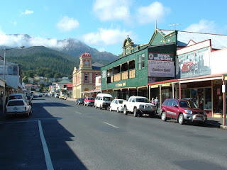
The following day we went to Stanley - an attractive and historic
coastal town most well known for The Nut. This is an extinct
volcano that we climbed and then walked around the top of. It
provided wonderful views both out to sea and back over the town
itself. After lunch at the beautiful Table Cape we headed south
to town of Strahan on the rugged west coast. We only had time
for a drive through before going out to Ocean Beach to camp for the
night.
 |
| Highfield Historic Site, Stanley |
Our next destination was the mining town of Queenstown. To get
there we had to traverse the extraordinary Lyell Highway that winds
its way through a surreal, almost apocalyptic landscape of eroded
gullies and scarred hillsides. This is the legacy of environmentally
destructive mining and the town itself has a pioneer feel to it. The
other option of travelling from Strachan to Queenstown is on the West
Coast Wilderness Railway which is a four-hour train journey through
dense forest and over wild rivers.
 |
| Mining town of Queenstown |
Southeast from Queenstown is the Franklin-Gordon Wild Rivers National
Park where I hiked to the Franklin River before we continued on
to Mount Field National Park. It was late afternoon but we
just had time to do a two-hour walk to see the Russell, Horseshoe and
Lady Baron Falls. All very pretty but would have been
impressive with more water. At the end of summer, much of
Tasmania seemed to be dry and brown. We also walked though the
'Land of Giants', an area of huge swamp gums - the world's largest
flowering plant. The tallest one stands at a massive 79 metres.
In the National Park, we drove up to Lake Dobson which is over a
kilometre above sea level. It was cold up there so we decided
to camp out in the enclosed shelter instead of pitching tents.
Despite the rather threatening weather, we walked to one of the
alpine lakes in the morning before leaving for Hobart. It was
nice to have the luxury of electricity, a comfortable bed and hot
shower after all that.
 |
| Old bridge and church of Richmond |
We didn't have long to catch our breath because we were on the road
to the Tasman Peninsula the next morning. It was a day where we
had to dodge a few showers but it wasn't too bad. Our first
stop along the way was the former military outpost and convict
station of Richmond. Today it is a historic town featuring an old
stone road bridge and various 19th century buildings
including churches, courthouse and gaol. We also stopped at the
Tessellated Pavement which is a beach where the fascinating rock
formations look like a stone pavement.
 |
| Tessellated Pavement |
The Tasman Peninsula was chosen in 1830 as a ‘natural penitentiary’
to confine convicts. Port Arthur became the hub of a network of
penal stations on the peninsula and some 12,500 convicts did hard
prison time until 1877. Today it is a place that is full of a
sombre, confronting and even haunting history. It’s a poignant
contrast of a bleak past set against the genuine beauty of carved
stonework, gothic architecture, green lawns and fine gardens. Even
the unsettled weather of the day seemed appropriate.
 |
| Convict penitentiary, Port Arthur |
The entry fee to the historic site included a harbour cruise and
40-minute guided tour of the settlement. I would love to have
spent longer there but the three hours gave me a good chance to learn
a lot. The various buildings once sustained convict labour
industries such as timber milling, ship building, coal mining,
shoemaking and brick and nail production. Tragically, on 28 April
1996 35 people were killed and a further 37 were left injured by a
crazed gunman at Port Arthur. Within the site there is a special
memorial garden for those who died in this massacre.
No comments:
Post a Comment